The first best purchase I ever made towards my running career was a simple pair of running shoes. They were Nike Air Max Assail II trail runners bought for $89 at a highway-side outlet in Minnesota. I never noticed they were trail running shoes. I didn’t bother with stride style or supination. I tried them on and they fitted both my feet and budget like gloves. Basically, I bought them because I liked the way they looked.
They lasted me well over 1500 km without flinching. I only changed them after 3 years because I was worried to see everybody else rotate their shoes much earlier. But I suspect I ran better in these than in my current Asics. Oh, that Nike model? Of course they don’t make them any more.
The second best purchase ever, well, that only happened this year (2009). I was leaving Vancouver and my all-time favourite Seawall route behind and was quite worried about what lay ahead in New York in terms of running paths. It felt like I would never find anything as good as Stanley Park and would have to get used to streets again. I would have to spend hours on the Gmaps Pedometer plotting multiple routes and calculating possible and probable distances.
So I was weak. I invested in a Garmin Forerunner 305 personal trainer, a heart rate monitor with integrated GPS capability. Equipped with the little beauty, I’d be able to follow my progress in real time and break free from pre-run distance calculations. I would be able to improvise and adjust to the Eastern Seaboard.
I’ve now been running with the Forerunner for almost a year. My last 3 trail runs down here in South Africa relied on it heavily. I simply love it. It is the most extraordinary tool and I seriously doubt I would be able to accomplish as much without it. Despite the obvious heart rate monitoring – which I am not really using these days, having temporarily stopped interval training when I left Vancouver – the Forerunner offers a multitude of features that really all boil down to this: its GPS capability allows for real-time tracking of distance vs speed and time.
That’s it. It’s that simple. With a glance at my watch, I know instantly how long I have been running, and how far. And what remains ahead if I’ve plotted a training course. This makes such a huge difference in terms of pacing myself, I can’t imagine running without it any more. I can double-back and run in my tracks, I can follow a previously uploaded route, I can run against myself to improve time, I can choose paces, heart rate zones and speeds at will, backed up by alarms to stay within chosen parameters. I have direct access to sunrise and sunset times, I can mark interesting spots as way-points, and later, everything gets uploaded to either of my 3 favourite pieces of training software, on the laptop or online, and the run is fully detailed and mapped onto Google maps.
Yesterday’s run once again led me over Table Mountain. Marie had a meeting in downtown Cape Town with an editor and dropped me off at 3:00 PM a little beyond the lower Cableway station, at the base of Platteklip Gorge. Platterklip reminds me very much of Vancouver’s Grouse Grind. Steep, straight up, painful, it took me a bit under an hour to climb. Two major differences here, though: the South African mid-day heat – it was about 27 deg. C – and its consequence, a welcomed absence of crowds. I couldn’t choose my window, having caught a ride, but I  would recommend going much earlier in the day, or later.
In any case, no running up Platterklip for me, I don’t train on uphills often enough to manage it. And with 13 km to go once at the top, the name of the game was pacing. I was bringing along two energy gels and two Powerade bottles. I also knew I could count on water at the beginning of the Jeep track, near the reservoirs.
Platterklip, just like the Grind, is basically a long staircase. Initial elevation: 400 meters ASL. I started in the sun and eventually got some shade as the two walls converged on me and water sang weakly in the gorge, despite the summer. I sucked an energy gel two thirds of the way up. Towards the top, legs a tad shaky, I met up with an unrelenting sun again but the wind finally picked up as I came out onto the plateau at 55 minutes. A signpost indicated the cable car station to the right, and Maclear’s Beacon to the left.
I aimed for the latter, running on a pleasantly flat trail of large rocks and some sand, and reached the beacon at 1:15 hrs. Altitude, 1087 meters. I snapped a few shots and pushed on.
From Maclear’s Beacon, I was on known territory. I negotiated the long descent on the Smuts Track, passed Skeleton Gorge (a tempting shortcut back home) and Nursery Ravine (an even more tempting shortcut to home and the swimming pool) and eventually came upon the beginning of the Jeep track, at 2:00 hrs sharp.
I filled my empty bottle with a water that is most probably drinkable but, as with all fresh water on the table, looks a little yellow and doesn’t really inspire me. I had Powerade left and decided to use the fresh water for cooling off, the sun still fiercely frying the top of the mountain.
The steep Jeep track is quite easy on the way down as long as I pay close attention to my knees. At the Constantia Nek, I took a sharp left and 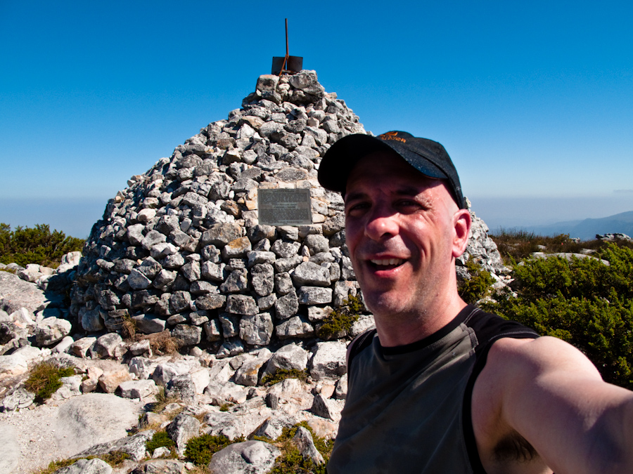 followed a trail into Cecilia, descending and crossing the road into the top of the Green Belt and running down a bit faster on my last reserves, like a horse smelling the barn.
I arrived on Brommersvlei Rd. at 2:47 hrs. The Powerade was gone, and so were my reserves.
Once home, I drank a ton of water and jumped into the pool. The dogs looked worried, either about my redish face or about the risk of drowning. Theirs.
Beautiful run.
Comments
Vince